Uma Oya Power Station

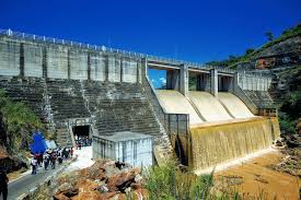
The Uma Oya Hydropower Complex, also known as the Uma Oya Multipurpose Development Project (UOMDP), is an irrigation and hydroelectric system in Sri Lanka’s Badulla District. The project, first assessed in 1989 by the Central Engineering and Consultancy Bureau, aims to improve both power generation and agricultural irrigation in the region. It involves constructing a dam across Dalgolla Oya, a tributary of Uma Oya, and channeling water through a 3,975-meter (13,041 ft) tunnel to Mathatilla Oya, another tributary. At Mathatilla Oya, a second dam is built to divert 145 million cubic meters (5.1 billion cubic feet) of water annually via a 15,290-meter (50,160 ft) headrace tunnel to the underground Uma Oya Power Station.
The power station is equipped with two Pelton turbine generators, each with a 60 MW capacity, and is fed by a 600-meter (2,000 ft) vertical pressure shaft. The station, capable of generating up to 120 MW of power, is projected to produce 231 GWh annually. The 68,000 cubic meters (2.4 million cubic feet) of earth removed to create the underground cavern reflects the large scale of the project.
Power is delivered via a 132kV double-circuit transmission line, extending 21.5 kilometers (13.4 miles) to the Badulla Substation. This line is supported by over 70 transmission towers. The project’s agricultural component is significant as well, with 145 million cubic meters of water discharged annually through a 3,335-meter tailrace tunnel. This water irrigates 15 square kilometers (5.8 sq mi) of existing land and 45 square kilometers (17 sq mi) of newly cultivated land, benefiting 14 separate tanks.
- Installed capacity 60 MW X 2
- Expected annual average energy 290 GWh
- Commissioned in 2024
- Main contractors
- Civil – Farab
- Electromechanical – ANDRITZ HYDRO
- Hydro mechanical – Farab
- Located 13 km North of Wellawaya
- Reservoir
- Puhulpola
- Catchment area : 180 km2
- Usable water volume : 0.09 MCM
- Maximum level : 986 m above MSL
- Minimum level : 985 m above MSL
- Link Tunnel (Free flow)
- Length : 3.72 km
- Diameter : 4.5 m
- Dyraaba
- Catchment area : 157 km2
- Usable water volume : 0.61 MCM
- Maximum level : 976 m above MSL
- Minimum level : 965 m above MSL
- Headrace
- Circular concrete lined + Unlined
- 4 to 4.5 m diameter
- 15,650 m length
- Penstock
- Circular Steel vertical, 2.2 m diameter, 618 m Height
- Tailrace tunnel
- Length : 3600 m
- Slope : 0.1 %
- Generator (ANDRITZ)
- Conventional vertical
- 71750 kVA, 0.85 PF, 10.5 kV, 3950 A
- 50 Hz, 10 poles, 600 rev/min
- Exciter : 180 V, 1200 A
- Turbine (ANDRITZ)
- Vertical Pelton (6 Jets)
- Output : 62.2 MW @ 722 m of net rated head
- Rated discharge : 9.6 m3/sec
- 600 rev/min
- Puhulpola